Route Overview |
Course Markings
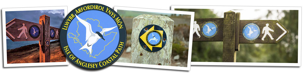
The route is marked by Anglesey Coastal Path signposts, which come in different forms but always display the Tern and yellow arrow which are the guides on this route - see the examples below.
Dedicated Ring O' Fire signs will mark the route to the night's accommodation and any diversions.
While the route is well signposted, there are occasional areas where it can become unclear, for instance when travelling through large fields or areas of woodland. You also may find sections where signposts are hard to spot, especially at night when tiredness creeps in and visibility is limited. See our Hazards page for advice on night-time navigation.
Maps and navigation
The route is detailed on our downloadable Map Pack.
Note the 2025 map pack will only be made available around two weeks before the start of the race to allow for any last minutes route diversions.
We encourage the use of the traditional map and compass for navigation and the final route will be that detailed on the 2025 maps. Indicative GPX route profiles for both the Ring O' Fire and Firelighter will be available on this page for download about two weeks prior to the start.
While advanced navigational skills are not necessary, a basic level of navigation competency is required. Runners are advised to carry a map, compass and GPS device.
A degree of self-sufficiency, the ability to look after yourself and make sound judgement calls is mandatory. This is not a race where we hold your hand and offer full support all the way around. Checkpoints can have many miles between them and the terrain is challenging. The weather can change quickly and you could face many hours running through the night in cold, wet and windy weather conditions.
Aside from our map packs and the GPX files, we recommend the Ordnance Survey Maps of Anglesey West and East (1:25,000) or Hardy Anglesey Coastal Path XT40 (1:40,000).
More information on the Isle of Anglesey Coastal Path is available at the Isle of Anglesey Council website.
What do people say about us?
"Dearest Ring O' Fire bods, thank you so much for an epic weekend! That was total nails, and I feel like I've earned every single last one of those 5 UTMB points. Could I just ask the marshalls who were in the half-way checkpoint, if they have my grey Arc'teryx running top? A bloke was running with me for awhile with no waterproof kit (I know. Lol) so I gave it him to wear. He then dnf'd at that half-way checkpoint. I was told by another runner he had handed it in. It's my favourite running top!! Please, please, please... just let me know if it's amongst the gear and I'll happily pay for the postage for its return. I have a photo if that helps (I just cant seen to upload it to this page). Thank you, Lucie"
Past Ring O' Fire finisher